Managing landscape character and scenic amenity for the City of Busselton
- Client Name
- City of Busselton
- Location
- Busselton, Western Australia
Challenge
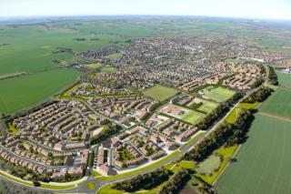
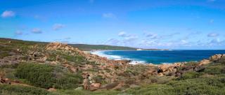
The City of Busselton required a robust and defendable planning framework to protect the highly valued scenic qualities of the Cape to Cape Track Corridor and surrounding coastal environments. Increasing development pressure from tourism, residential growth and rural subdivisions risks were eroding the distinctive landscape character that underpins the region’s identity, visitor economy and community values.
Key challenges included:
- Establishing a clear spatial relationship between visual sensitivity, building exposure, and development height.
- Providing advice for integrating existing Special Control Area provisions informed by the geospatially based viewshed mapping.
- Providing evidence to support height controls and scenic management zones through the local planning scheme.
Solution
SLR undertook a comprehensive state and local landscape literature review, visual landscape assessment, guided by the local planning framework, using geospatial and visual exposure modelling to identify areas where development could visually impact the Cape to Cape Track experience.
The key components included:
- Viewshed modelling: 204 georeferenced observer points at 200m intervals along the track, modelled with a 1.65m eye height and 6.5km visibility buffer.
- Building height sensitivity mapping: Exposure mapping for building heights at 7.5m and 12m to identify lots visible from the track and key ridgelines.
- Land use and zoning review: Evaluation of City of Busselton zoning data and Leeuwin-Naturaliste Ridge policy boundaries to identify development typologies requiring landscape management.
- Planning integration: Alignment with the City’s Special Control Area 9 – Cape to Cape Track Landscape Value Area and the broader provisions under the Local Planning Scheme to ensure new development maintains visual integration and scenic quality.
Our multi-disciplinary team combined landscape planning, geospatial analysis, and visual impact assessment to provide the City of Busselton with clear, defendable policy guidance for development control applied within it’s local planning scheme.
Impact
The study informed a new Local Planning Policy (Managing Landscape Character and Scenic Amenity) and Special Control Area, that will guide development applications within the Cape to Cape track visual catchment.
Key outcomes include:
- Establishment of a policy-supported visual sensitivity layer for use in development assessment.
- Identification of height-sensitive zones and precinct-specific design guidance for Cape Naturaliste, Yallingup, Smiths Beach, Injidup and Wilyabrup.
- Strengthen Special Control Area No. 9 provisions, including the requirement for Landscape Character and Visual Impact Assessment (LCVIAs) for new development proposals.
- Enhanced protection of the Cape to Cape Track experience, supporting both local tourism and the City’s sustainable growth objectives.
This study positions the City of Busselton to better protect the Cape to Cape Track from future development including visual encroachment and ensuring the preservation of its outstanding scenic landscapes and the distinctive character that defines the region.
“A well-executed project that was based on definable data and sound theory. The project provided the City with a basis to prepare its own visual landscape protection policy and then incorporate height limitations, materiality and built form controls within its draft Local Planning Scheme No.22. The SLR project team was professional and serviced this project in a timely and efficient manner, supporting the City in the protection of this important regional asset from unsympathetic development that would have an impact on the natural landscape values.”
Warren Giddens, Strategic Planning Coordinator, City of Busselton